
Or the COGESAF's Approach to WWPR
The Context:
In Quebec, the Water Withdrawal and Protection Regulation (WWPR) requires source vulnerability reporting every five years from entities withdrawing water from municipal water networks that supply at least 500 people.
This regulation is comparable to the provisions of the water safety management plans employed in France and elsewhere in the world, in the spirit of the European Union’s Water Framework Directive and the World Health Organization’s guidelines for drinking water quality.
The Client:
The mission of the COGESAF (Saint-François Watershed Steering Committee) is to achieve integrated water resource management in an area of 9,000 km2 territory located in southern Quebec, between the St. Lawrence River and the U.S. border.
The COGESAF is very familiar with the state of water resources in its territory and already had a significant portion of the information required to carry out the vulnerability analyses prescribed by the WWPR. Therefore, four municipalities located on its territory have mandated the COGESAF to carry out the vulnerability analyzes of their drinking water intakes and to generate the reports that must be submitted to authorities.
The Challenge:
The collection, processing, value enhancement, and long-term storage of the information needed to perform vulnerability analyzes is a major challenge.
For each drinking water intake, it is necessary to:
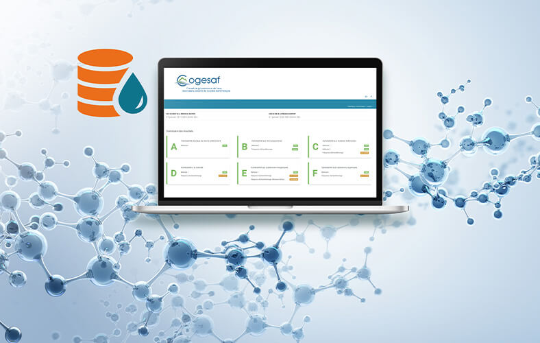
1) characterize withdrawal sites and drinking water production facilities, then determine the level of vulnerability of the water withdrawn based on six predefined indicators, namely:
- physical vulnerability of the withdrawal site
- vulnerability to microorganisms
- vulnerability to fertilizing materials
- vulnerability to turbidity
- vulnerability to inorganic substances
- vulnerability to organic substances
2) identify elements that may affect the quality and quantity of water collected
- anthropogenic activities
- potential events
- land use
3) assess the threat potential posed by the inventoried elements
4) identify causes that may explain documented problems
5) generate vulnerability analysis reports for drinking water sources.
In addition, the WWPR must be applied across the catchment areas of the water supply intake. Since several water intakes are located on the territory covered by the COGESAF, this requires collation of a large amount of data from various sources. It was therefore necessary first to standardize the data collected.
The Solution:
To sort its data to prepare vulnerability analyzes, the COGESAF acquired Enki, WaterShed Monitoring’s water data management tool. Designed specifically to centralize water data management, Enki supports metadata, which promotes data standardization and facilitates the exchange of information between stakeholders.
Once the initial configurations were completed, the WaterShed Monitoring team trained the COGESAF staff to help them become familiar with their new work tool.
The team also supported the COGESAF in its efforts to answer to the WWPR requirements by helping validate existing data and metadata, as well as identifying gaps. Once all water quality data was validated, the COGESAF team inputted it into the Enki software so that it could automatically calculate vulnerability levels for each of the six targeted indicators (step 1).
As for the land occupancy data (steps 2 and 3), WaterShed Monitoring IT experts retrieved and inputted into Enki data from various sources provided by the COGESAF to inventory and locate anthropogenic activities taking place on the concerned portions of its territory, using geolocated land use codes.
In addition, WaterShed Monitoring experts have developed a standardized worksheet to simplify the assessment of threats posed by listed activities. Each existing code has been methodically associated with a list of contaminants whose risk potential is weighted according to the severity of its environmental consequences and the frequency of release.
At this stage, collaborative work between WaterShed Monitoring and COGESAF teams helped refine the threat assessment sheet, particularly regarding the inclusion of some anthropogenic activities for which there was no code.
A custom-developed algorithm then links the threat assessment sheet to geographic data, creating flows capable of automatically generating summary tables in accordance with the Quebec government’s recommendations.
This innovation, from which the COGESAF has benefited, has greatly contributed to simplifying and accelerating the vulnerability analysis process, while increasing the robustness of the results obtained.
“In addition to allowing us to concentrate all the information necessary for the report required by the WWPR, Enki allows us to have a global view of the withdrawal site, the distribution network and the activities in the different protection areas.” –Julie Grenier, COGESAF
The Results:
The COGESAF successfully carried out vulnerability analyses for the municipalities and delivered the analysis reports to the Government of Quebec within the established timetable.
The ease of use of the Enki system and the gains in time and efficiency convinced the organization to continue using WaterShed Monitoring’s platform. By regularly updating its water data, the COGESAF is taking a step ahead in producing the next vulnerability analysis reports, expected by the government in 2026.